


After flying over it for years, last September (2016) I decide it was finally time to paddle the Nitinat Triangle. Despite the “Triangle” having been a recognized canoe route for at least three decades there is, unfortunately, very little information available. It lies within in Pacific Rim National Park but Parks Canada makes no reference to it either online or in their printed literature. As it turns out, Parks Canada is no longer maintaining the Nitinat Triangle Canoe Circuit. A fact which they’ve failed to published anywhere.
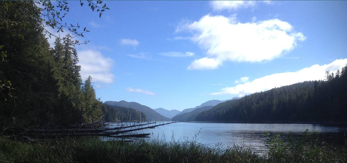
 The first morning out I paddled up Nitinat Lake facing only a light breeze (Nitinat is known for it’s strong Westerly winds.). The day was warm and I’d forgotten that Nitinat is a saltwater lake, so was a little concerned for my dog, until I found a freshwater stream and filled my water bottles. I found Hobiton Creek without difficulty but had read that lining the creak is prohibited due to its being salmon spawning habitat. With some searching I managed to locate the portage in a small rocky cove just to the west of Hobiton Creek. It’s marked only by a handful of floats hanging from a tree 30 feet up on a rock bluff.
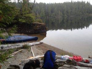
To reach the start of the portage one must first navigate a jumble of driftwood jamming the beach. Then there is a near vertical assent of 20-30 feet over jagged slippery rocks. I decided to take my pack over first and spec out the trail. Fresh boot prints proved someone else had at least walked the trail recently. What would have been a challenging portage under any circumstances has been made down right dangerous by years of neglect. I would classify it as an extreme hiking trail. Dragging a canoe over it, especially solo, is not for the feint of heart. Had I know the condition of the portage, prior to setting out I would never have attempted this trip solo.
 Hobiton Lake, however, was worth the suffering. The portage ends in a small swampy cove but after a few minutes of paddling opens onto a breathtakingly beautiful wilderness lake, bordered by steep banks of mature second growth forest, and no sign of “civilization” anywhere. Because of the steep banks there is really only one all weather camping area on the lake, where Hitchie Creek empties into Hobiton Lake. There are however several possibly camp sites on this mini delta. As,by time I finally reached the lake, night was coming on fast, I pulled in to the first spot I found and stayed there for two glorious nights, exploring the lake, swimming and even doing a little fishing.
On the third day I set off early in search of the Hobiton-Tsusiat Lake portage. There was a lot of windfall driftwood which made scoping the shore difficult and I only found the head of the portage with the aid of a small remnant of plastic bag tied to a tree at the lake shore. Again, there was no signage of any kind. Thank you Parks Canada.
 I was encourage to find that someone had recently done some work on the first part of the portage. The Hobiton-Tsusiat Lake portage is bisected by a small, shallow slew which proved navigable even with very low September water levels. There is a trail around the slew but a lot of trees had fallen across it making it impassible. Unfortunately, whoever had done the clearing, stopped at the slew, making the second, much longer, stretch of the portage hard going. It had not been cleared in years but was still in much better shape then the Nitinat-Hobiton Lake portage. It is a rugged, long and challenging portage which took me most of the day to traverse solo. Tsusiat Lake however was well worth the effort.
By time I reached Tsusiat Lake and had all of my gear, as well as my scruffy four legged friend, safely aboard darkness was falling. I was fortunate in finding a tiny white sand beach on the northern shore where I made camp, cooked my dinner and watched the stars come out. While a great little camp site in fair weather and low water, I would not recommend camping there in wind and weather.
The next day clouds loomed but the day was still warm and the wind low so I set about exploring Tsusiat Lake. I first went looking for the old portage/trail up to Squalicum Lake, but if it still exists, I couldn’t find it. Again there is really only one all weather camp site on Tsusiat Lake which is located on the southern shore. This is reserve land belonging to the Ditidaht People. If you’re planning on camping on Tsusiat Lake please contact the band and get permission. Apparently there was once a year round settlement on this site where ocean going canoes were carved and laboriously transported down to the coast. This is a place deserving of respect.
 That afternoon I once again found myself looking for a portage. The inlet between Tsusiat and Little Tsusiat Lakes was jammed with drift wood but I was able to portage around this with some difficulty. However, once on little Tsusiat I couldn’t find the start of the portage even though I’ve been told historically there were two portage trails, one on either side of Tsusiat Creek. I believe now the start of the portage was on Tsusiat Lake proper, to the south of the inlet between the two lakes. Stumped I attempted to line the creak, having been told this was possible. I got maybe half a kilometer down the creak, and was ready to turn back, due to tons of windfall jamming the creak bed, when I spied the portage on the south shore.
I managed the to drag my pack and canoe up to the portage figuring I was home free. Not so, this portage makes the west coast trail look like a sidewalk. I later learned that two of the park wardens had attempted it with day packs and turned back. In it’s present state, it’s just not possible to solo overhead carry a 16′ canoe over this trail. It’s completely overgrown and hasn’t been maintained in probably a decade. I managed to get my pack out to the camp site at Tsusiat Falls where I spent the night, hoping to find some help the next day to retrieve my canoe.
 In hind site I should have turned back and retraced my steps but I didn’t. I also had no luck in finding help with the canoe. What’s more it had started raining hard which turned out to be to be a blessing as I push, pulled and dragged my canoe over the overgrown portage. Mud and wet Salal made doing this possible whereas had it remained dry I doubt I could have done it. Finally I lowered my canoe by rope down the ladders by the Tsusiat Falls camp site and was on the beach.
That night the first of the winter storms hit changing the angle of the beach, exposing rocks, and making the surf much more challenging then it had been all summer. The park rangers told me they’d been landing their Zodiac there all summer but could no longer do so. After three days of waiting for the waves to calm I ended up portaging my boat over the West Coast Trail to the Narrows and finally Nitinat Lake.
The Nitinat Triangle is without doubt one of the most spectacular and challenging canoe circuits I have ever done. The scenery is amazing, the water fresh and clear and it lies within a Nation Park. It also provides a fourth access point to the West Coast Trail. Many of the dangers I faced on this trip were a direct result of Parks Canada not making it clear they were no longer maintaining this amazing canoe route. I don’t think it was unreasonable on my part to expect a long established canoe route, withing a National Park, to at least have signage?
 I hate the thought of this spectacular canoe route fall from use but, as it is, parts of it are dangerous. If it weren’t within a National Park, and David Pacey had not been charged last year for “contravening the National Park Act” (clearing trails with a Swede saw), I would attempt to organize a work party to clear and repair the portages. I don’t know what the solution is and welcome any suggestions any of you may have.
On a closing note, I have since found out you are allowed to line Hobiton Creek with prior permission from the Nitinat Fisheries. This would give you access to Hobiton without having to brave the the first horrendous portage.
Hello. I’m read your blog on Nitinat, just before I headed out to do it myself and the thing I’m most curious about is whether or not you found Silver spring?
Congratulations on completing this circuit, I did it myself back in 2003 and I think it was even worse back then. Luckily I had a kevlar canoe that weighed only about 50lbs but I did about $1500 in damage to the hull dragging it over the deadfalls. I can say that in all these years, you are the only other person I have heard of who actually got down to the falls. I managed to radio a boat that agreed to meet us out on the ocean if we could paddle past the breaking surf and take me back to the Nitinat Narrows, and even though it was August, it took five or six tries to launch the canoe in those breaking waves at Tsusiat Falls.
Thanks for your story!